Madison, Nashville: a neighborhood report
Last checked
About 180 of the Madison properties that flooded in May 2010 sit outside today’s high-risk flood zones. Metro counted 459 properties with damaged buildings in the ZIP code, most of them houses. So the flood map alone won’t tell you which streets took water.
Madison sits north and east of downtown Nashville, along Gallatin Pike. The Cumberland River curls around its south and east sides, and the land inside the big loop is called Neely’s Bend. The ZIP code is 37115, and we use its outline here.
Madison isn’t its own city. It has been part of Metro Nashville since the city and county merged in 1963. Most of it is in Metro Council District 9. Slices fall in Districts 3, 5, 7 and 10.
Where the water went in 2010
Two kinds of water flood Madison. The Cumberland River backs up into the low ground along its banks. And small creeks, such as Gibson Creek and Dry Creek, rise fast in heavy rain.
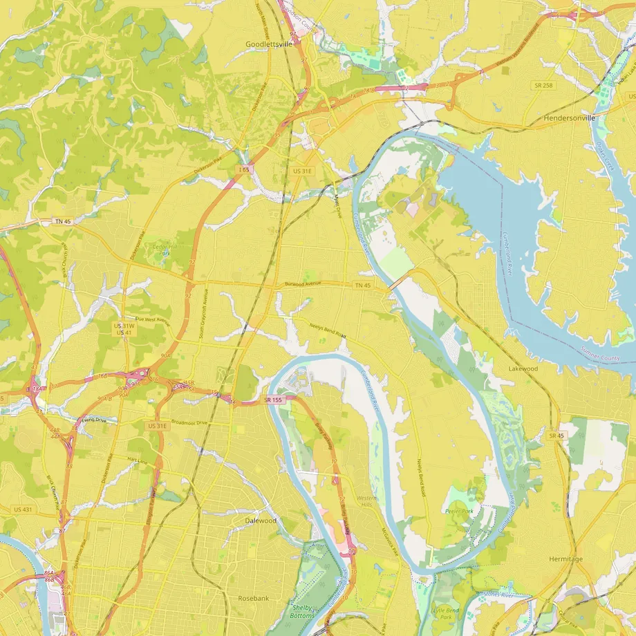
On FEMA’s current maps, roughly an eighth of Madison’s land is in a high-risk flood zone. You can see the bands along Gibson Creek near Yale Avenue and in the bottomland of Neely’s Bend.
In 2010 the water didn’t stop at those bands.
Metro has bought out some of the worst-hit homes. By 2019 it had bought 30 properties along the creek near Harrington Avenue, Fox 17 reported. Before you buy, ask the seller directly about 2010. Get a flood insurance quote even if the lender doesn’t require one. Our guide to why flood maps disagree explains the gap.
Wind is the other risk. On December 9, 2023, an EF-2 tornado crossed Madison on its way to Hendersonville and Gallatin. The National Weather Service counted three deaths in Madison.
What’s under the yard?
Limestone. Nashville sits on it, and limestone dissolves slowly in groundwater. That can open sinkholes, and a U.S. Geological Survey study put the Nashville area among the places where they’re common. A soft spot or a depression in the yard is worth a question to your inspector.
The EPA puts Davidson County in its highest radon zone. A radon test costs little and is worth adding to the inspection.
Houses from the 1950s to the 1980s
Madison grew around a stop on the Louisville and Nashville Railroad. Madison Station got its post office in 1857. The railroad built Amqui Station in 1910. Johnny Cash bought the old depot in 1979 to save it from demolition. Today it stands in Madison again as a museum and visitor center.
Most homes came much later. About three in ten were built in the 1950s and 1960s, and another three in ten in the 1970s and 1980s. Nearly one in five is from 2000 or later. Just under half of homes are detached houses. About a third are in apartment buildings of five or more units. Roughly 43% are lived in by their owners, and three in four heat with electricity. Those figures come from the Census Bureau’s 2020–2024 survey.
In a house from the 1950s or 1960s, have the wiring, the panel, the roof and the drain line to the street checked.
Gallatin Pike is changing
Gallatin Pike is Madison’s main street, and most of the new building is on it. Station A, 292 apartments on Gallatin Pike North, finished construction in October 2025. A developer plans a much larger project, called Madison Station, around the old Madison Square shopping center. Its first phase is 242 affordable apartments.
Just north of Madison, RiverGate Mall closed in February 2026. Demolition started in March. A $450 million plan will replace it in phases with over 700 apartments, townhomes, shops and a hotel. Dillard’s is staying.
Transit is changing too. In 2024 Nashville voters approved a sales-tax plan for transit. It names Gallatin Pike as a main corridor, with dedicated bus lanes and a new transit center in Madison. The Nashville Banner reported in June 2026 that construction on the corridor isn’t expected before 2030.
In December 2025 the Metro Council passed a bill that makes backyard cottages easier to build on many lots inside the Urban Services District. That district covers about half of Madison’s land, but not Neely’s Bend. Check the final rules with Metro Codes before you plan one.
Getting around
I-65 runs along the west side. Briley Parkway and Ellington Parkway link Madison to the rest of the city. From Gallatin Pike at Madison Station Boulevard, downtown Nashville is about 9 miles by road and the airport about 14.
WeGo’s route 56 on Gallatin Pike has run every 15 minutes since July 2025, evenings and weekends too. Routes 76 and 79 also serve Madison.
A CSX freight line runs through the middle of Madison. At the Williams Avenue crossing, federal records show about 13 through trains a day, about half of them at night. That crossing isn’t in a quiet zone, so trains sound their horns there. Look at a house’s distance from the tracks.
Weekends
Peeler Park fills the tip of Neely’s Bend. It covers about 600 acres of river bottom, with a greenway, horse trails and a boat ramp onto the Cumberland. It’s about 6 miles by road from Gallatin Pike.
On Sundays from April to October, a farmers market sets up at Amqui Station on Madison Street. It ran again in 2026. Old Hickory Lake is a short drive east, and Shelby Bottoms, a large riverside park, is about 6.5 miles south by road.
The practical list
- Utilities: Nashville Electric Service for power. Gas comes from Spire Tennessee, which took over from Piedmont in March 2026. Madison Suburban Utility District supplies water, and Metro handles sewer.
- Trash: Metro picks up at the curb inside the Urban Services District. Outside it, including Neely’s Bend, homes hire a private hauler.
- Shopping: Kroger and a Walmart Neighborhood Market are on Gallatin Pike in Madison. The Target and Walmart Supercenter at Rivergate are under 4 miles away. The nearest Costco is in Hendersonville, about 9 miles. Opry Mills is about 7 miles.
- Hospitals: TriStar Skyline Madison moved its services away in August 2024. TriStar Skyline Medical Center on Dickerson Pike is about 3 miles by road.
- Schools: Metro Nashville Public Schools. Its school finder shows the zoned schools for an address.
- Property tax: homes are assessed at 25% of appraised value. For 2025, Metro’s rate was $2.814 per $100 of that inside the Urban Services District and $2.782 outside it. A $350,000 house in the urban district works out to about $2,460 a year. Check a house’s actual bill.
- Climate: at Nashville’s airport, about 50 inches of rain and melted snow a year, with under 5 inches of snow. The USDA plant hardiness zone, which gardeners use, is 7b.
Facts on this page were checked against public records and news reports on November 3, 2026.
Explore it yourself
Open the map over Madison with flood zones and noise switched on, then add what matters to you.