Wayne, New Jersey: a town report
Last checked
On August 29, 2011, after Hurricane Irene, the Pompton River reached 25.24 feet at the Pompton Plains gauge. That gauge is just across the river from Wayne, and flood stage there is 16 feet. It was the highest crest in records going back to 1903.
Wayne is a township of 24 square miles in Passaic County, New Jersey, about 21 miles by road from Midtown Manhattan. The 2020-24 Census survey puts its population at about 54,000. Its ZIP code is 07470. Most of the town is outside FEMA’s high-risk flood zones. The low ground along its western and southern edges is where the trouble is.
Where does Wayne flood?
The Pompton River runs along the western edge of town and meets the Passaic in the south. Water from a big stretch of northern New Jersey has to squeeze through that meeting point. So after three inches or more of rain, the rivers back up. Flooding can start a day or more after the rain stops and last for several days. FEMA’s current maps for Passaic County took effect in April 2020. Their high-risk zones follow the rivers around Mountain View and Willowbrook Mall and reach up the smaller streams.
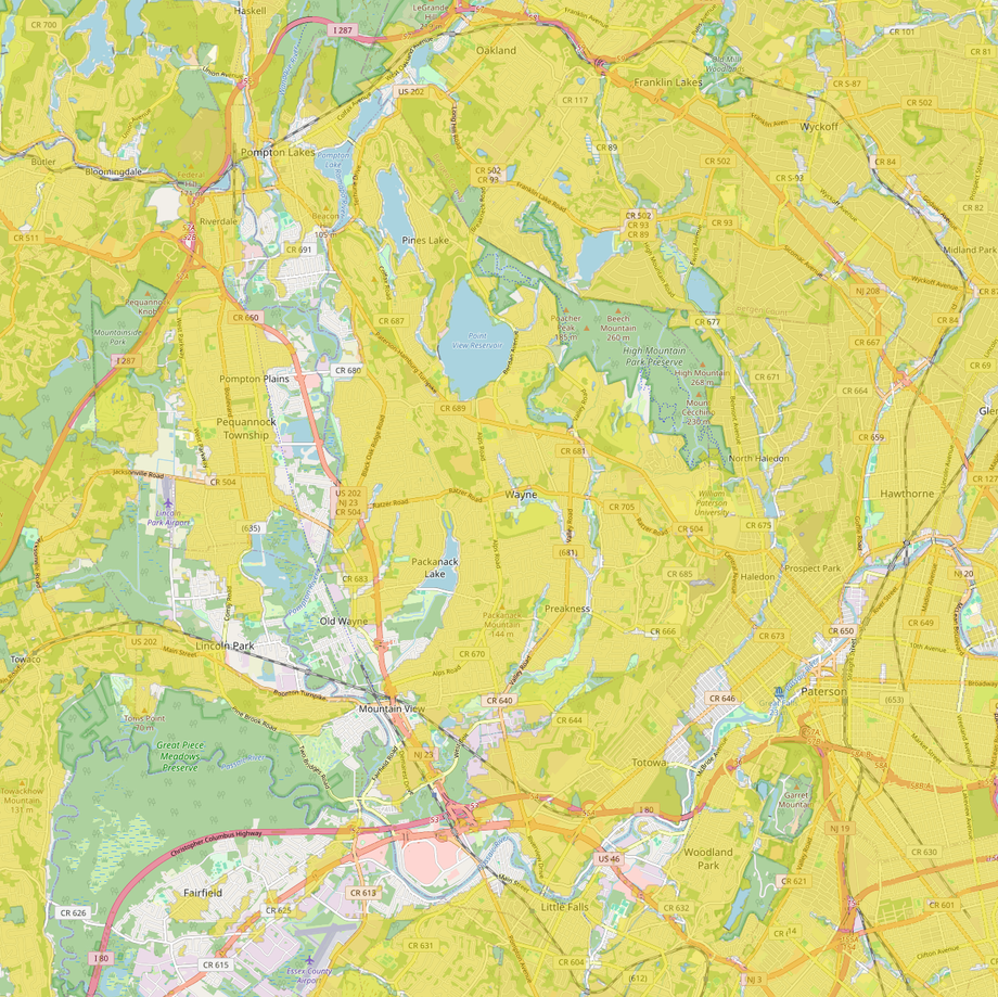
The township has spent years moving people out of the lowest ground. By 2017 it had lined up about $91 million in federal and state grants to buy out 394 flood-prone homes. Many were in the Hoffman Grove section by the Pompton. The houses come down, and the land stays open. Flooding still reaches homes that remain. In December 2023, water entered houses near the Pompton and the town was under a state of emergency.
Two state rules help a buyer here. Since March 2024, sellers must tell you whether a home is in a FEMA flood zone and answer questions about its flood history. And since July 2023, a new or rebuilt house in a river flood area needs its first floor 2 feet above the state’s flood level. Our guide to reading a FEMA flood map explains the zone letters.
The houses
Wayne was built out fast after World War II. Its population went from about 11,800 in 1950 to about 49,100 in 1970. The 2020-24 Census survey puts the median home’s construction in 1967, with 44% built between 1950 and 1969 and only about 1% since 2010. About two-thirds of homes are detached single-family houses.
Nearly nine in ten homes heat with natural gas. Some older ones burned oil first, so ask whether the house ever had a buried oil tank and whether it was removed with a permit. If a tank leaked, the cleanup runs under state rules and usually falls on the owner.
Wayne also has lake neighborhoods, such as Packanack Lake and Pines Lake. Their associations collect yearly dues for the lakes and beaches. Ask what the dues are and whether joining is required before you make an offer.
What’s being built
The largest housing project already approved is on the former GAF office campus at 1361 Alps Road. It has 439 townhouses and 10 houses, and was approved in October 2023. The builder expects it to take six years or more. Under state rules, Wayne must plan for 1,000 new affordable homes from 2025 to 2035, plus repairs to 162 existing ones; it filed that plan in June 2025. On the industrial side, a new warehouse of about 70,000 square feet at 125 Pompton Plains Crossroad found a tenant in March 2026.
A short history
George Washington made the Dey Mansion on Totowa Road his headquarters in July 1780, and again that fall. It’s now a county museum, open Wednesday to Sunday; adult admission is $5. The township was formed in 1847 and named for General Anthony Wayne. The Morris Canal once crossed its southwest corner, carrying coal and produce until the railroads took over.
From 1948 to 1971 a plant on Black Oak Ridge Road extracted thorium and rare-earth metals and buried its waste on site. The federal government cleaned it up over the following decades. The EPA confirmed the work complete in 2003, and the site was cleared for unrestricted use and taken off the Superfund list in 2012.
Shopping
Willowbrook Mall, near where Routes 23 and 46 meet, is the regional mall, and it’s in town. So is a Costco on Route 23, about 4 miles from Town Hall. Garden State Plaza in Paramus is about 11 miles east. The township farmers’ market runs Saturdays, 9 to 2, at Town Hall from May to late November. A winter market at the Community Center on Pike Drive starts December 5, 2026.
What locals do for fun
High Mountain Park Preserve covers about 1,260 acres in the northeast of town. It’s owned by the township, The Nature Conservancy and the state. The summit is about 885 feet up, and on a clear day you can see the New York skyline from it.
In summer, residents can buy a membership to the James W. Roe Memorial Pool on Garside Avenue. It has a flume ride and a zero-depth area. Captain Kilroy Park has a swimming lake with a sand beach, open to non-residents too. The township puts on free outdoor concerts at the Community Center and Town Hall through the summer. Wayne Day, the town fair, is held at the municipal complex in September; in 2026 it was September 27. For skiing, Campgaw Mountain in Mahwah is about 14 miles away and Mountain Creek in Vernon about 32. MetLife Stadium is about 14 miles.
Getting around
Routes 23, 46 and 202 cross the town, and Interstate 80 runs along its southern edge. NJ Transit’s Montclair-Boonton line stops at Mountain View and the Wayne/Route 23 Transit Center, weekdays only, so check the timetable. Buses, including the 194 and 324, run to the Port Authority Bus Terminal. By road from Town Hall:
- Paterson about 4 miles, Morristown about 19, Midtown Manhattan about 21.
- Newark Liberty airport about 22 miles, LaGuardia about 28.
Services, taxes and climate
- Government: a mayor and a nine-member council, three elected at-large and six by ward, under the mayor-council form Wayne adopted in 1962.
- Fire and ambulance: five volunteer fire companies, and the Wayne Township Memorial First Aid Squad, founded in 1943. St. Joseph’s Wayne Medical Center on Hamburg Turnpike, about 2 miles from Town Hall, has a 24-hour emergency department.
- Electricity and gas: PSE&G supplies gas and most of the power. Some neighborhoods, including Pines Lake, get electricity from JCP&L instead.
- Water and sewer: the township runs both and bills quarterly. Its water comes mainly from the Wanaque Reservoir system.
- Trash and snow: the Department of Public Works collects trash and recycling at the curb on a zone schedule. It also plows the township’s more than 960 streets.
- Schools: the Wayne Public Schools district. William Paterson University’s campus is also in town.
- Property tax: the 2025 rate was $5.998 per $100 of assessed value. That’s about $15,000 a year on a $250,000 assessment. Wayne’s assessments run well below market value, about 38% of it in 2025. So that tax works out to roughly 2.3% of what the house would sell for.
- Climate: at Essex Fells, about 7 miles south, roughly 49 inches of precipitation a year, summer highs around 83°F and winter lows around 24°F. The hardiness zone is 7a.
Facts on this page were checked against township, county, state and federal sources on November 2, 2026.
Explore it yourself
Open the map over Wayne with flood zones, transit stops and parks switched on, then add what matters to you.