Clear Lake, Houston: a neighborhood report
Last checked
Most of Clear Lake sits outside FEMA’s high-risk flood zones. Parts of it flooded in Hurricane Harvey anyway, so water is the first thing to look at here.
Clear Lake is the part of Houston that grew up around NASA’s Johnson Space Center, about 22 miles by road southeast of downtown. Most of it is in ZIP codes 77062 and 77059, home to about 44,000 people.
Where does Clear Lake start and stop?
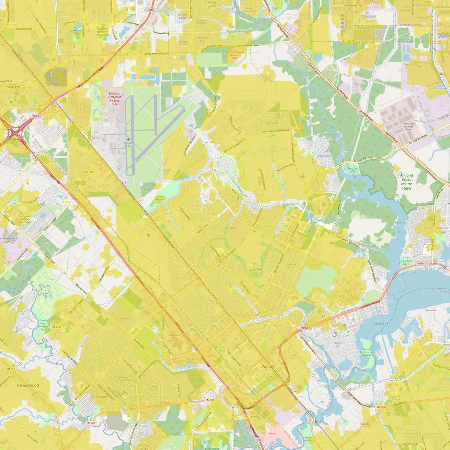
The city draws it as the Clear Lake super neighborhood, about 24 square miles. It takes in the space center, Baybrook Mall and land on both sides of Interstate 45. Webster, a separate small city with ZIP code 77598, lines its southern edge. Clear Lake is in City Council District E, which also covers Kingwood, more than 30 miles north.
Humble Oil owned the ranch land here from 1938. NASA chose the area for its new spacecraft center in 1961, and Humble’s development company began laying out Clear Lake City soon after. The water authority and the community association date from 1963. Houston annexed the area in 1977, over a “Free the Clear Lake 25,000” campaign. Lawsuits over that annexation helped push Houston to elect most of its council by district.
Does it flood?
In places, yes. FEMA’s high-risk zones here follow Horsepen Bayou and the ditches that feed it. They also cover land on both sides of I-45 south of Ellington, and part of the space center campus near the lake. Together that’s about 7% of the area. The maps in force took effect in January 2017.
Seven months later came Harvey. A rain gauge on Clear Creek at I-45 recorded almost 23 inches in 24 hours. The county flood control district has said some homes near Horsepen Bayou took 20 to 30 inches of water.
The biggest local fix since then is Exploration Green. The old Clear Lake golf course, closed in 2005, is now five detention ponds on 178 acres. Together they hold about 500 million gallons. The water authority finished the last phase in 2023. Even half-dug, the first pond kept water out of at least 150 homes during Harvey. In 2023 the county dropped a $12.5 million plan to widen Horsepen Bayou, partly because Exploration Green had already cut the risk for many homes.
New FEMA maps are on the way. Drafts came out in February 2026 but don’t affect insurance yet. County officials have said they may not be final until 2028. Our guide to reading a FEMA flood map explains the zone letters.
What about hurricanes?
ZIP codes 77059 and 77062 are in Zip Zone B of the region’s evacuation plan, told to leave after the coastal zone and Zone A. Both were under evacuation orders for Hurricane Ike in 2008. NASA’s review of Ike lists Nassau Bay and Kemah, its neighbors on the lake, among places with a 15- to 20-foot storm surge.
Insurance needs a closer look than usual. The state’s windstorm pool covers only a few Harris County cities east of Highway 146, and Clear Lake isn’t among them. Wind cover has to come from an ordinary homeowners policy, and flood cover is always a separate policy. Our guide to finding a home you can still insure covers what to ask before an offer.
What’s under the house?
Clay, mostly. The federal soil survey maps about half of Clear Lake as Lake Charles clay. It swells when wet and shrinks in dry spells, which moves and cracks slab foundations. Get a foundation inspection, and ask whether the slab has ever been repaired.
How old are the houses, and what can you change?
In 77062 the median home dates from 1980, and eight in ten went up between 1960 and 1989. In 77059, mostly north of Horsepen Bayou, the median is 1993. Few homes have been added since 2020: about 3% of the homes in 77059 and almost none in 77062. Most are detached single-family houses.
Houston has no zoning. What you can build is set mostly by the deed restrictions recorded for each subdivision. The city attorney’s office can enforce the ones on use, setbacks and lot size. Read them before you plan an addition, a garage apartment or a business at home.
Much of the original Clear Lake City also belongs to the Clear Lake City Community Association. It enforces deed restrictions and runs a recreation center on Diana Lane, plus pools and parks. It hasn’t raised its annual assessment since 1963. Now it is asking each section to adopt an extra charge, paid only by owners who buy after July 1, 2026. Voting runs until June 2029, so ask whether a house’s section has adopted it.
What’s being built?
Not much housing. The growth is next door at Ellington, which doubles as the Houston Spaceport. Axiom Space, Intuitive Machines and Collins Aerospace opened buildings there in 2022 and 2023.
What do people do for fun?
Armand Bayou Nature Center, just east of the neighborhood, has about 5 miles of trails and a bison viewing platform. It also runs kayak tours and pontoon cruises on the bayou. Adult admission is $7, and it’s closed Mondays and Tuesdays. Exploration Green adds six miles of trails around its ponds. For boats, the county’s Bay Area Park and Clear Lake Park both have ramps.
Space Center Houston, the space center’s official visitor center, runs tram tours onto the space center campus. Its holiday light show, Galaxy Lights, returns in November 2026. The community association’s recreation center holds a spring fest and a fall festival. Kemah Boardwalk is about 11 miles by road, and Galveston’s Stewart Beach about 35.
How far is everything?
You’ll mostly drive. I-45 runs along the west side and NASA Parkway along the south. By road from the middle of the neighborhood:
- Downtown Houston and the Texas Medical Center, each about 21 to 22 miles.
- Hobby Airport, about 12 miles; Bush Intercontinental, about 40.
- A Kroger on El Dorado Boulevard, about 1.5 miles; H-E-B stores, about 3.
- A Walmart Supercenter and a Sam’s Club on El Dorado, about 3 miles. Home Depot is about 3, Lowe’s about 4, Baybrook Mall about 4, and the Costco in Webster about 5.
METRO’s Park & Ride buses leave lots on Bay Area and El Dorado boulevards for downtown on weekdays, using the I-45 HOV lane. NASA’s jets fly from Ellington, along with military and private planes.
Services, taxes and weather
- Water and sewer: much of the area is served by the Clear Lake City Water Authority. A bill for 10,000 gallons ran about $58 in mid-2026, before a 6% increase that took effect in October.
- Trash: city curbside pickup. Since July 2026 the city has charged a $5 monthly fee for it, which the city has said will rise.
- Electricity and gas: CenterPoint runs the lines. You buy electricity from a retail company you choose.
- Hospitals: HCA Houston Healthcare Clear Lake and UTMB’s Clear Lake campus, both in Webster, about 4 miles away. Houston Methodist Clear Lake in Nassau Bay is about 5.
- Schools: the Clear Creek Independent School District.
- Property tax: the 2025 rates for the city, the county and its districts, Clear Creek ISD and the water authority add up to about $2.36 per $100 of value. On a $350,000 house that’s about $8,300 a year before exemptions. A homestead exemption lowers it for an owner who lives there. Taxing units vary by address, so check the appraisal district’s record.
- Climate: at Hobby Airport, about 56 inches of rain a year and August highs around 93. The hardiness zone is 9b.
Facts on this page were checked against city, county, state and federal sources on November 2, 2026.
Explore it yourself
Open the map over Clear Lake with flood zones, parks and transit switched on, then add what matters to you.