Downtown Jersey City: a neighborhood report
Last checked
When the Dutch arrived, Paulus Hook was an island at high tide. Salt marsh separated it from a second patch of high ground called Harsimus. Through the 1800s the marshes were filled and the railroads pushed the shoreline out into the Hudson. The result is downtown Jersey City, and that old map still decides which blocks flood.
The edges, and who runs it
Downtown is the part of Jersey City between the New Jersey Turnpike Extension and the Hudson River. It runs from the Hoboken line south to the Morris Canal Basin. It takes in Paulus Hook, Van Vorst Park, Hamilton Park, Harsimus Cove, Newport and the office towers around Exchange Place. Most of it is ZIP code 07302. The waterfront towers use 07310 and 07311.
There’s no separate local government. Jersey City has a mayor and a nine-member council, with six members elected by ward and three citywide. Most of downtown is in Ward E. The 2022 ward map moved some downtown blocks into neighboring wards, so check an address before assuming.
The flood map follows the old shoreline
The original high ground around Van Vorst Park, Hamilton Park and Grove Street sits outside FEMA’s high-risk zones. The waterfront from Newport down to Exchange Place is mostly Zone AE. There, FEMA expects a flood with a 1% chance each year to reach about 9 feet above sea level. A band of filled blocks between Hamilton Park and Grove Street is in Zone AE too.
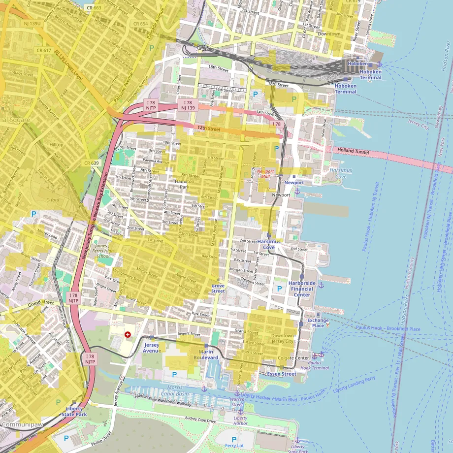
These FEMA maps date from 2006. In October 2012, Hurricane Sandy’s storm surge pushed into low streets downtown and flooded the Exchange Place PATH station. Our guide to reading a FEMA flood map explains the zone letters.
Two state rules matter to buyers. Since March 2024, New Jersey sellers and landlords must tell you whether a home is in a FEMA flood zone and whether it has flooded. And since January 2026, the state’s REAL rules apply to new buildings and major rebuilds near tidal water that need a state flood permit. They must plan for water 4 feet above today’s 100-year flood level.
Most homes are in big buildings
Downtown has two kinds of housing and not much in between. In its three ZIP codes, about two in three homes are in buildings with 50 or more units. More than half were built since 2000. Nearly one in five dates from before 1940. Those are mostly the brick and brownstone row houses on the historic blocks. Only about one occupied home in five is lived in by its owner.
With a pre-war row house, have the roof, plumbing and wiring inspected. Ask whether the water line to the street is lead. The Jersey City Municipal Utilities Authority plans to replace about 16,000 lead service lines citywide by 2031. In 2022 it also agreed with federal regulators to spend over $1 billion on its sewer and water systems over 10 years. The city’s sewers are a combined system, so rain and sewage share the same pipes.
Four historic districts
Paulus Hook, Van Vorst Park, Hamilton Park and Harsimus Cove are all city historic districts. Inside them, work on a building needs a sign-off from the Historic Preservation Commission before it starts, and that includes repairs. Staff approve most small jobs. Additions, rooftop work, new buildings and demolitions go to the full commission. Ask a seller for the approvals behind any recent work.
More than a dozen projects at once
In August 2026, the local site Jersey Digs counted more than a dozen major projects underway downtown. The Everton tower at 99 Provost Street opened a large ShopRite on its second floor in October 2026, replacing the older store on Marin Boulevard. Tishman Speyer is building a 924-unit tower at 50 Hudson Street, due in 2028. A Trader Joe’s is expected at 55 Hudson, probably in 2027 once the tower finishes. Near the Hoboken line, a 530-unit tower is rising at 20 Long Slip, and Harborside 8 is going up at 68 stories.
Two older landmarks are changing hands. The 1908 Powerhouse once made the electricity for the trains that became PATH. It’s set to pass from the Port Authority to the city once a new substation beside it is finished. And in 2025 the city settled a long fight over the Sixth Street Embankment, a stone-walled former rail line. The deal clears the way for a park on most of it, with new buildings allowed on part.
Shopping
Groceries are close, with the new ShopRite on Provost Street. Newport Centre is a two-level indoor mall with Macy’s, Kohl’s and a Primark. A Target at 100 14th Street is about 1.4 miles by road from Grove Street. The nearest Costco is in Bayonne, about 6 miles, and the nearest Walmart Supercenter is in Secaucus, about 7.
Weekends center on Newark Avenue
Newark Avenue and the plaza beside the Grove Street station are where downtown gathers. The Historic Downtown farmers’ market sets up on the plaza on Monday and Thursday afternoons from late April. Hamilton Park has its own market on Wednesday afternoons. In August 2026 the plaza had free concerts every Wednesday. Newark Avenue hosts the All About Downtown street fair each September and the city’s Pride festival in August.
The Hudson River Waterfront Walkway runs along the shore, with Lower Manhattan across the water. Liberty State Park starts just south of the Morris Canal Basin. The Liberty Science Center is about 2 miles by road, and ferries leave the park for the Statue of Liberty and Ellis Island. Red Bull Arena is about 7 miles away and MetLife Stadium about 9.
Getting to Manhattan without a car
PATH trains from Grove Street, Exchange Place and Newport run to the World Trade Center and to 33rd Street in Midtown. The Hudson-Bergen Light Rail stops along the waterfront and south toward Liberty State Park. NY Waterway ferries leave Paulus Hook for Brookfield Place and Pier 11 in Manhattan, and for West 39th Street at weekday rush hours.
Drivers have the Holland Tunnel, whose New Jersey end sits at 12th and 14th Streets, and the Turnpike Extension along the west edge. By road from Grove Street, Newark Airport is about 11 miles, LaGuardia about 13 and JFK about 21. Our guide to living without a car covers what to check before you give one up.
Taxes, utilities and weather
- Property tax: Jersey City’s 2025 general rate was $2.335 per $100 of assessed value. On a home assessed at $600,000, that’s about $14,010 a year. Assessments ran at about 80% of market value, so the effective rate was about 1.85%. In August 2026 the council raised the city’s share of the rate by about 15%, the condition of a $120 million state package, most of it a loan. The increase starts with the third-quarter bills.
- Utilities: PSE&G supplies electricity and gas. The Jersey City Municipal Utilities Authority runs water and sewer.
- Hospital: Jersey City Medical Center is about 0.7 miles from Grove Street.
- Schools: Jersey City Public Schools. Check the district’s school finder for an address.
- Climate: at Newark Airport, the nearest long-running weather station, about 47 inches of precipitation and 31 inches of snow fall in a typical year.
Facts on this page were checked against city, state and federal sources on November 2, 2026.
Explore it yourself
Open the map over downtown Jersey City with flood zones, transit and walkability switched on, then add what matters to you.