The Flatiron District, Manhattan: a neighborhood report
Last checked
New York City doesn’t draw official neighborhood lines, so where the Flatiron District stops depends on who you ask. Most people mean the blocks around the Flatiron Building, from Union Square at 14th Street up to Madison Square Park. East to west, that’s about Park Avenue South to Sixth Avenue. Most of it is in ZIP code 10010.
For census figures, the city groups it with NoMad, Herald Square and Union Square in one area called Midtown South-Flatiron-Union Square. The housing numbers on this page are for that larger area.
Will it flood?
Not according to FEMA. The whole neighborhood sits outside the federal high-risk flood zones. The Flatiron Building and Union Square are both in Zone X, the lowest-risk group. The high-risk zones start closer to both rivers, at Waterside Plaza on the East River and along Eleventh Avenue by the Hudson.
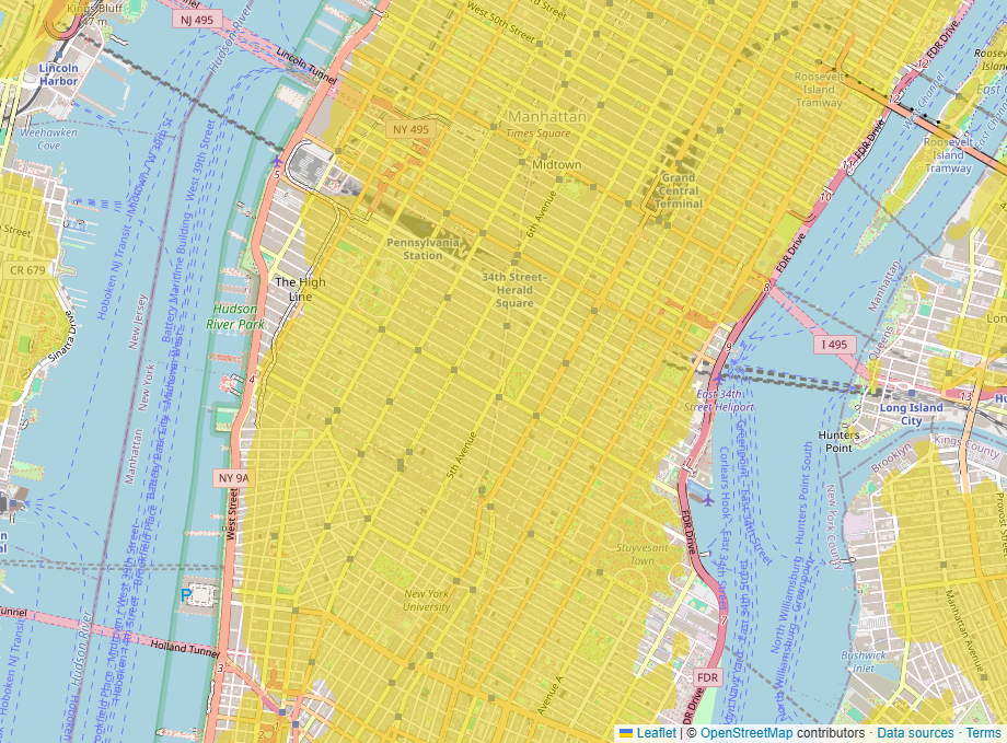
Dry ground didn’t keep the lights on during Hurricane Sandy, though. In October 2012 the East River surged into Con Edison’s substation on East 14th Street. Most of Manhattan below 39th Street lost power for several days. Flatiron was inside that line. Ask whether a building has a backup generator. The FEMA maps in force for the city date from 2007, and our guide to reading a FEMA flood map explains the zone letters.
Old buildings, new rules
The housing here is mostly apartments in older buildings. In the city’s census area, about 40% of homes are in buildings from 1939 or earlier, and about a third were built since 2000. About seven in ten households rent. Most apartments that come up for sale are co-ops or condos. A co-op board has to approve a buyer, and many co-ops charge a transfer fee, called a flip tax, when a unit sells.
Two city rules land on owners through the building’s budget. Buildings taller than six stories need a facade inspection every five years. Repairs can mean sidewalk sheds and a one-off charge to owners. Since 2024, buildings over 25,000 square feet have had carbon limits under Local Law 97, and those limits get stricter in 2030. Ask the board or managing agent for the latest facade report and the building’s carbon plan.
Old buildings and old streets come with old materials. In July 2018 a Con Edison steam pipe laid in 1932 burst under Fifth Avenue near 21st Street. Its casing held asbestos, and 49 buildings were evacuated. Inside a prewar apartment, expect lead paint and asbestos to be possible, and read the inspection closely.
Noise is the everyday issue. Federal traffic-noise estimates put Sixth Avenue near 60 decibels averaged over a day, and the side streets between the avenues around 45 to 50. That estimate counts traffic only. It leaves out sirens and rooftop equipment, so visit at night and on a weekday morning.
Landmark districts and what’s being built
Much of the neighborhood is a city historic district. Ladies’ Mile, designated in 1989, covers about 380 properties. Its stores and lofts went up between the Civil War and World War I, when big department stores lined Broadway and Sixth Avenue here. North of the park, the Madison Square North district followed in 2001. In either one, exterior work such as new windows, storefronts or a rooftop addition needs a permit from the Landmarks Preservation Commission.
The Flatiron Building itself, finished in 1902, is being turned mostly into condos, with move-ins planned for fall 2026. Bigger change is coming to the north and west. In August 2025 the City Council rezoned 42 blocks between West 23rd and 40th Streets, from Fifth to Eighth Avenue. New homes are now allowed on blocks once zoned for manufacturing. The city expects about 9,500 new homes there over time. On Broadway, a plaza and two-way bike lane opened between 17th and 21st Streets in 2024. The city plans to rebuild 21st to 27th Streets as a mostly car-free street by 2031.
Shopping
Yes, there’s a big-box store: a Home Depot on West 23rd Street between Fifth and Sixth Avenues. For food there’s Eataly at 200 Fifth Avenue, and Whole Foods and Trader Joe’s on Union Square. The Union Square Greenmarket runs year-round on Mondays, Wednesdays, Fridays and Saturdays. Macy’s and a Target are at Herald Square, about 11 blocks up Broadway. The nearest Costco is in Long Island City, about 5 miles by road, with another in East Harlem about 6. The Shops at Hudson Yards are about a mile and a half.
What people do for fun
Madison Square Park is the front yard, with lawns and a rotating outdoor sculpture show. This year’s pieces, by Roberto Lugo, stay up through December 6. The first Shake Shack opened as a kiosk in the park in 2004 and is still there.
Two museums are a few blocks apart. The National Museum of Mathematics is now at Sixth Avenue and 19th Street, open daily. The National Park Service runs Theodore Roosevelt’s birthplace at 28 East 20th Street, Wednesday to Sunday, with the upstairs rooms on guided tours. Madison Square Garden is about a mile away. The Hudson River Park waterfront is about 1.3 miles west by road, and Central Park about 2 miles north. Yankee Stadium is about 8.5 miles by road, Citi Field about 11, and Rockaway Beach about 18.
Getting around
The subway lines are close on every side. The R and W run under Broadway, the 6 under Park Avenue South and the F and M under Sixth Avenue. Eight lines stop at 14th Street–Union Square. PATH trains to New Jersey stop along Sixth Avenue at 14th, 23rd and 33rd Streets. Penn Station is about 1.2 miles by road and Grand Central about 1.3.
If you do drive in, the whole neighborhood is inside the congestion toll zone south of 60th Street. Since January 2025 most cars with E-ZPass have paid $9 to enter at peak times. By road, LaGuardia is about 9 miles, Newark about 14 and JFK about 17.
Bills, taxes and weather
- Utilities: Con Edison supplies electricity and gas. City water and sewer are billed to the building.
- Trash and snow: the Department of Sanitation collects household trash, which must go out in lidded bins, and plows the streets. Building owners clear their own sidewalks.
- Hospitals: Bellevue and NYU Langone, both on First Avenue, are each about a mile away.
- Schools: New York City Public Schools, District 2. The city’s school search shows the zoned schools for an address.
- Property tax: co-ops and condos are in Class 2, taxed at 12.439% of assessed value for the 2026 tax year. Assessed value is set by the city and is usually far below the sale price. On a $100,000 assessment the bill is $12,439 before abatements. Co-op owners pay their share through monthly maintenance.
- Buying costs: New York State’s mansion tax is 1% on a home of $1 million or more, paid by the buyer. That’s $12,000 on a $1.2 million apartment. The rate rises above $2 million. Residents also pay city income tax on top of the state’s.
- Climate: at Central Park, about 50 inches of rain and melted snow a year and 30 inches of snow. January highs average about 40°F and July highs about 85°F. Plants rated for USDA zone 7b survive the winters here.
Facts on this page were checked against city, state and federal sources on November 2, 2026.
See it on the map
Open the map over the Flatiron District with flood zones, transit and noise switched on, and add whatever else you care about.