Crown Heights, Brooklyn: a neighborhood report
Last checked
Every block in Crown Heights is within about half a mile of a subway station. This part of central Brooklyn runs from Atlantic Avenue south to Empire Boulevard, and from Washington Avenue east toward Ralph Avenue. Eastern Parkway cuts across the middle. ZIP code 11213 covers much of it. The edges spill into 11216 and 11225, which mostly cover the neighborhoods next door.
The parkway roughly divides Brooklyn Community Boards 8 and 9, and the area is split among City Council Districts 35, 36 and 41.
Four subway lines under the parkway
The 2, 3, 4 and 5 all stop at Franklin Avenue. The 3 and 4 stop at Crown Heights–Utica Avenue, and the 3 alone at Nostrand and Kingston Avenues. The 2 and 5 branch south under Nostrand Avenue, with stops at President Street and Sterling Street.
On the west side, the Franklin Avenue Shuttle runs north and south. The A and C stop along Fulton Street, a couple of blocks north of Atlantic Avenue. The Long Island Rail Road has a station at Nostrand Avenue, where its line rises onto an elevated track above Atlantic.
By road from Eastern Parkway and Nostrand Avenue, Midtown Manhattan is about 11 miles. JFK and LaGuardia are each about 11 miles, and Newark’s airport about 18.
Big roads, quiet blocks
The street grid sorts traffic. Eastern Parkway has six lanes plus two service roads. Atlantic Avenue, on the north edge, is a truck route, and east of Nostrand Avenue it runs under the elevated railroad. Empire Boulevard carries traffic along the south. Nostrand, Utica, Bedford and Franklin Avenues run north and south. The blocks between them are mostly quiet side streets.
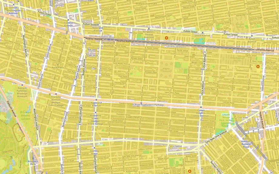
So the exact block matters. A house on the parkway faces its tree-lined malls and its traffic. One a block away may face a one-way side street. Our guide to finding a quiet neighborhood covers what to listen for when you visit.
Water in the basement
FEMA’s flood maps put Crown Heights in its lowest-risk zone. We checked six points from Atlantic Avenue to Empire Boulevard, and all came back Zone X. The risk here comes from heavy rain instead. When a storm drops more water than the sewers can carry, it backs up into basements.
During Ida in September 2021, the mayor said even parts of Brooklyn that rarely flood, Crown Heights among them, were overwhelmed. Record rain on October 30, 2025 flooded basements across the city again. A man died in a basement apartment on Kingston Avenue, a few blocks south of the neighborhood. The city has built hundreds of rain gardens and basins across Crown Heights to soak up water.
Ask whether the basement has ever flooded, and whether the house has a backwater valve, which stops sewage from flowing back in. Our guide to why flood maps disagree explains why a FEMA zone can miss this kind of flooding.
Old houses and the historic district
Across the three ZIP codes, about six in ten homes were built before 1940. Fewer than one in twelve went up after 2010. That’s from the Census Bureau’s 2020–2024 survey. More than a quarter are in buildings of two to four units, and about four in ten in buildings of 20 or more. Roughly one home in five is lived in by its owner.
Before the rowhouses, the area was farmland and the 19th-century village of Weeksville. Frederick Law Olmsted and Calvert Vaux laid out Eastern Parkway in the early 1870s. Its stretch west of Ralph Avenue became a city scenic landmark in 1978. Brownstone and limestone rowhouses went up through the early 1900s. The subway reached the parkway in 1920, and large apartment buildings followed.
Much of the north side is in the Crown Heights North Historic District, designated by the city in three phases: 2007, 2011 and 2015. Inside it, most changes to the outside of a building, from windows to stoops, need a permit from the Landmarks Preservation Commission.
Have the wiring and boiler inspected. About one home in ten still heats with fuel oil, so ask about any oil tank. Sellers of homes built before 1978 must disclose any lead paint they know about. The city’s City of Yes rules, passed in December 2024, allow basement, attic and backyard units in many one- and two-family homes. A basement unit carries the flood risk above.
Atlantic Avenue is being rezoned
In May 2025 the City Council approved the Atlantic Avenue Mixed-Use Plan. It rezones about 21 blocks between Vanderbilt and Nostrand Avenues, where only low industrial buildings had been allowed. The city expects about 4,600 new homes there over time, about 1,900 of them income-restricted. The plan also pays for park upgrades and 140 rain gardens.
In 2021 the City Planning Commission rejected two towers proposed at 960 Franklin Avenue, over the shadows they would cast on the Brooklyn Botanic Garden. A seven-story rental building with about 290 apartments opened there in 2026.
Owner chores in the city
- Sidewalks: the owner keeps the sidewalk in front in repair and clears snow. If snow stops between 7 a.m. and 5 p.m., you have four hours to clear a path. Fines start at $100.
- Trash: since June 1, 2026, buildings with one to nine homes must put trash out in an official NYC Bin. Warnings ended on September 7.
- Pipes to the street: the owner is responsible for the water and sewer lines between the house and the city mains.
Weekends
The Brooklyn Botanic Garden and the Brooklyn Museum sit on the western edge, and Prospect Park is a short walk beyond. The garden’s 200-plus cherry trees draw crowds each spring, so book tickets ahead. The Brooklyn Children’s Museum is on Brooklyn Avenue, open Wednesday to Sunday. At the Weeksville Heritage Center, the restored Hunterfly Road Houses reopened in 2026.
The old Bedford-Union Armory reopened in 2021 as the Major R. Owens Health and Wellness Community Center. It has a 25-meter pool, basketball courts and a soccer field. Brower Park and Lincoln Terrace Park are closer to home, and Franklin and Nostrand Avenues are lined with restaurants.
On Labor Day, the West Indian American Day Carnival parade runs along Eastern Parkway from Buffalo Avenue to Grand Army Plaza. It last ran on September 7, 2026. Expect closed streets and crowds. Barclays Center is about 2 miles away.
Errands
Groceries and pharmacies line the main avenues. There’s no big-box store inside the neighborhood. The nearest Target, at Atlantic Terminal, is about 2.4 miles by road, and a Home Depot in Bedford-Stuyvesant about 2. The Sunset Park Costco and Kings Plaza, Brooklyn’s large enclosed mall, are each about 5 miles.
Services, taxes and climate
- Utilities: Con Edison for electricity, National Grid for gas, and the city for water and sewer.
- Hospitals: Kings County Hospital is about 1.3 miles by road, and NewYork-Presbyterian Brooklyn Methodist about 2.2.
- Schools: New York City public schools. Use the city’s school search to find the zoned schools for an address.
- Property tax: houses of one to three units are Class 1. The city assesses them at no more than 6% of market value, and yearly caps often keep it lower. The 2025–26 rate was 19.843% of that assessed value, so a $50,000 assessment means about $9,920 a year before exemptions. The provisional rate for 2026–27 is 20.909%. Check a house’s actual bill.
- Climate: at Central Park, about 49.5 inches of rain and melted snow a year, with about 30 inches of snow. The hardiness zone is 7b.
Facts on this page were checked against public records and news reports on November 2, 2026.
Explore it yourself
Open the map over Crown Heights with quiet streets and transit switched on, then add what matters to you.