East New York, Brooklyn: a neighborhood report
Last checked
Stand on Pitkin Avenue at Shepherd Avenue and the C train runs right under your feet. Now walk a little over a mile southeast, to Stanley Avenue near the Queens line. There, the closest subway station is more than three quarters of a mile away. That split runs through East New York. It’s the first thing to know when you pick a block.
The city’s maps draw East New York from Atlantic Avenue and Fulton Street south to about Flatlands Avenue. East to west, it runs from the Queens line to Van Sinderen Avenue. Most of it is in ZIP codes 11207 and 11208. The 11208 code also covers Cypress Hills to the north. Spring Creek, to the south, has its own ZIP code.
Brooklyn Community Board 5 covers nearly all of it. Most of the area is in City Council District 42, and the rest is in District 37.
Four lines, one gap
The J and Z run on an elevated track above Fulton Street, along the north edge. The A and C run under Pitkin Avenue, with stops from Liberty Avenue east to Grant Avenue. The L runs down the west side toward Canarsie. The 3 runs above Livonia Avenue and ends at New Lots Avenue.
At the northwest corner, Broadway Junction links the A, C, J, Z and L. The Long Island Rail Road stops next door, at its East New York station.
We measured from every station. About three quarters of the neighborhood is within half a mile of one. The gap is the southeast corner, almost all of it below Linden Boulevard. From there, getting to a train usually means a bus or a walk of 15 minutes or more.
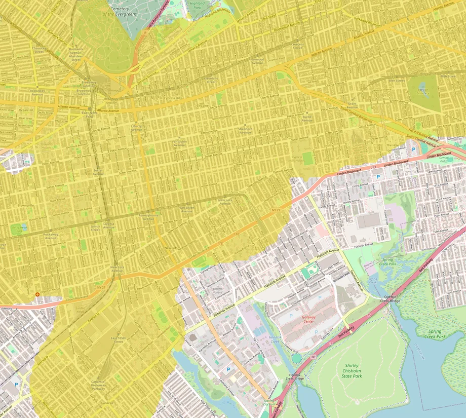
Elevated tracks are loud. Homes facing the trains on Fulton Street and Livonia Avenue hear every one go by. Our guide to living without a car covers what else to check if you’ll rely on transit.
Will the basement stay dry?
From rivers and the bay, mostly yes. FEMA’s flood maps put more than 99% of East New York in its lowest-risk zone. Only small patches at the southeast edge are in a high-risk zone.
From below, it’s less simple. In 1976 the U.S. Geological Survey reported flooded basements and damaged foundations across East New York. The cause was groundwater. Brooklyn stopped pumping drinking water from its wells in 1947. By 1976 the water table here had risen about 20 feet.
Heavy rain is the other risk. The city says its sewers are built for about 1.75 inches of rain an hour, and recent storms have dropped far more. Ask whether the basement has ever taken on water. Ask about a sump pump, and a backwater valve, which stops sewage from flowing back in. Our guide to why flood maps disagree explains why a FEMA zone can miss this kind of water.
The 2016 rezoning, ten years on
In April 2016 the City Council voted 45 to 1 to rezone about 190 blocks of East New York, Cypress Hills and Ocean Hill. It was the first rezoning under the city’s Mandatory Inclusionary Housing rules, which require a share of affordable apartments in new buildings. Atlantic Avenue can now take buildings of up to 14 stories with stores at street level.
Building has been slower than forecast. In 2023 The Real Deal counted about 600 new homes under the plan, against a forecast of 6,500. Projects are still arriving. The Highland, 320 apartments behind the landmarked Empire State Dairy buildings on Atlantic Avenue, began leasing in 2024. Just over the line in Cypress Hills, the third building of the Atlantic Chestnut affordable complex broke ground in April 2026.
In 2023 the city and the MTA announced about $500 million for Broadway Junction: seven new elevators, a new entrance and two public plazas. In May 2025, CBS New York reported the station work should finish by the end of 2027. Street work is due to start in 2028.
Since December 2024, the city’s City of Yes rules allow a basement, attic or backyard unit in many one- and two-family homes. A basement unit carries the water risk above.
Mostly two- to four-family buildings
More than four in ten homes here are in buildings of two to four units. About one in eight is a single-family house, and about one in five is in a building of 50 or more. A third were built before 1940, and about one in seven since 2000. Roughly one home in four is lived in by its owner. Those figures come from the Census Bureau’s 2020–2024 survey.
This was farmland in the old Dutch town of New Lots. In 1835 a Connecticut merchant, John Pitkin, bought land north of New Lots Avenue and named it East New York. Brooklyn annexed the town in 1886. Elevated trains on Fulton Street and Jamaica Avenue arrived in the late 1880s, and rows of frame and brick houses followed.
About a quarter of homes date from 1980 to 2009. Some are Nehemiah houses, rows built for owners to live in on empty city land, starting in the 1980s.
With older houses, have the wiring and the heating system inspected. Most homes heat with gas, but about one in 25 still uses fuel oil, so ask about an oil tank. Sellers of homes built before 1978 must disclose any lead paint they know about.
Shopping and driving
Gateway Center, just south of Flatlands Avenue, has a Target and a Home Depot among its big stores. It’s about 1.8 miles by road from Pitkin and Shepherd Avenues. The nearest big enclosed malls are Queens Center and Kings Plaza, each about 6 miles away.
Atlantic Avenue and Linden Boulevard carry most of the traffic. The Belt Parkway runs along the bay to the south. From Pitkin and Shepherd Avenues, JFK is about 7 miles by road and LaGuardia about 11. Midtown Manhattan is about 11 miles, and Newark’s airport about 20.
A state park and a Saturday market
Shirley Chisholm State Park sits on two capped landfills on Jamaica Bay, about 2.7 miles by road from Pitkin and Shepherd Avenues. It covers 407 acres, with 10 miles of trails for walking and biking. Its free Bike Library ran Thursdays to Sundays from April 30 to November 1 this year. Leave the dog at home. Pets aren’t allowed.
To the north, Highland Park climbs a ridge past the cemeteries, with playgrounds and a path around the old Ridgewood Reservoir. On Saturdays in summer and fall, the East New York Farms market sets up on Schenck Avenue between New Lots and Livonia Avenues. It ran again in 2026.
The practical list
- Utilities: Con Edison for electricity, National Grid for gas, and the city for water and sewer.
- Trash: since June 1, 2026, buildings with one to nine homes must put trash out in an official NYC Bin.
- Sidewalks: the owner keeps the sidewalk in repair and clears snow. If snow stops between 7 a.m. and 5 p.m., you have four hours. Fines start at $100.
- Hospitals: Brookdale Hospital is about 3 miles by road, and Jamaica Hospital about 5.
- Schools: New York City public schools. The city’s school search shows the zoned schools for an address.
- Property tax: houses of one to three units are Class 1, assessed at no more than 6% of market value. The 2025–26 rate was 19.843% of that, so a $40,000 assessment means about $7,940 a year before exemptions. The provisional 2026–27 rate is 20.909%. Check a house’s actual bill.
- Climate: at JFK Airport, about 43 inches of rain and melted snow a year, with about 26 inches of snow. The hardiness zone is 7b.
Facts on this page were checked against public records and news reports on November 3, 2026.
Explore it yourself
Open the map over East New York with transit and noise switched on, then add what matters to you.