Meadowview, Sacramento: a neighborhood report
Last checked
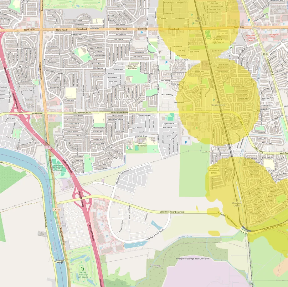
For twelve years, the Blue Line light rail ended at Meadowview Road. The line now runs on to Cosumnes River College, but two of its stations sit on Meadowview’s east edge. The neighborhood is at the south end of the city of Sacramento. The city’s neighborhood map draws it from Florin Road south past Cosumnes River Boulevard. From west to east, it runs from Freeport Boulevard and Interstate 5 to the rail line. ZIP codes 95822 and 95832 split it at about Meadowview Road. Most of it is in City Council District 8.
How close is the train?
Close, if you live on the east side. Meadowview station opened in 2003 at 3501 Meadowview Road. In 2015 the line was extended 4.3 miles south, and Morrison Creek station now serves the neighborhood’s southeast corner. West of 24th Street, the walk gets long.
Through 2026 SacRT has been raising Blue Line platforms for its new low-floor trains, Meadowview’s among them. The work runs into 2027. Stretches of two or three weeks at a time have closed stations, Meadowview included, with shuttle buses filling the gap. If you’re weighing a move without a car, our guide to living without a car covers what to check.
What keeps the water out?
Levees. The Sacramento River passes just beyond the neighborhood’s southwest corner, and Morrison Creek runs along its south edge. FEMA’s flood map puts the neighborhood in Zone X, marked as an area with reduced flood risk because of a levee. Every point we checked, from Florin Road to Delta Shores, carries that label.
Reduced is not zero. Federal rules don’t require flood insurance there, and a standard homeowners policy doesn’t cover floods, so the choice is yours. In 2014, after upgrades to Morrison Creek’s walls, FEMA dropped the insurance requirement for more than 1,000 homes along the creek. The work goes on. In August 2026 the Sacramento Area Flood Control Agency proposed raising and strengthening about three miles of the Morrison Creek and Beach Lake levees. A FEMA grant pays part of the cost. Our guide on why flood maps disagree explains what a levee zone does and doesn’t promise.
What’s under the houses
The federal soil survey maps two main soils here. Galt clay, found around LeVar Burton Park and in other pockets, swells when it’s wet and shrinks as it dries. That can crack slabs and shift foundations. San Joaquin silt loam, around the community center on Meadowview Road, has a dense clay layer about two feet down. Under both sits hardpan, a cemented layer roughly two and a half feet deep. Water and roots have trouble getting through it, so yards can drain slowly. A foundation inspection is money well spent.
The houses are mostly older. The Census Bureau’s 2020-24 survey covers six tracts that make up most of Meadowview. In them, 64% of homes were built before 1980. The biggest single group, 27%, dates from the 1960s, and about 78% are single-family houses. Homes wired between 1965 and the mid-1970s may have aluminum branch wiring. The Consumer Product Safety Commission has tied it to overheating at outlets and switches. Have an electrician look.
What you can build
Sacramento rewrote its rules in 2024. The 2040 General Plan, adopted that February, limits how big a building can be on its lot instead of counting units. That September an interim ordinance allowed duplexes and other small multi-unit buildings in single-family zones. The permanent version is expected to reach the City Council around the end of 2026. Few owners have used it so far: by late March 2026 the city had approved 22 such projects, nearly all duplexes.
State law also lets owners add a backyard cottage, or split one lot into two under SB 9. Since July 2026, SB 79 has allowed denser housing near qualifying transit stops. The regional planning agency lists both of the neighborhood’s stations as qualifying.
Two big pieces of land
The south end is where things are changing. Delta Shores is an 800-acre development planned for more than 4,900 homes and 1.3 million square feet of shops. Its northern part falls inside Meadowview. New houses were still being sold there in 2026. A 576-unit apartment project near Interstate 5 is due to finish by the end of 2026.
Just north of it, the city bought 102 empty acres from the federal government in January 2022 for $12.3 million. The land lies south of Meadowview Road and north of Cosumnes River Boulevard. A youth sports complex, housing, shops and a park have all been discussed. As of early 2026, the land was still empty and no plan had been chosen.
Shopping
Meadowview has its own Walmart Supercenter, at the Delta Shores center by Interstate 5. In 2022 the center’s other tenants included Hobby Lobby, Dick’s Sporting Goods, Ross, PetSmart and Ulta. The Home Depot on Florin Road is about 3 miles by road from Meadowview Road, and the nearest Costco, in Elk Grove, about 8. For a full mall, Arden Fair is about 12 miles north, and Westfield Galleria in Roseville about 27.
What locals do for fun
The Pannell Meadowview Community Center is at 2450 Meadowview Road. The city pool next door charges adults $4 for a recreation swim. The city’s Bill Conlin Youth Sports Complex sits by Interstate 5. The Martin Luther King Jr. Regional Library is on 24th Street. Richfield Park became LeVar Burton Park in 2019, named for the actor, who grew up in the area.
For open country, Stone Lakes National Wildlife Refuge is a short drive south, past the city limits. Its Blue Heron Trails are free and open daily, and sandhill cranes are among the birds to look for. For big events, the Kings play at Golden 1 Center downtown. River Cats baseball is just across the river, at Sutter Health Park in West Sacramento.
Getting around
Interstate 5 runs down the west side, and Highway 99 is a few miles east. Downtown is about 10 miles by road, roughly 15 minutes without traffic. Sacramento International Airport is about 20 miles away. Sacramento Executive Airport, a general-aviation field for smaller planes, sits about a mile north of Florin Road.
Services, taxes and climate
- Power: SMUD, the community-owned utility, supplies electricity, and PG&E supplies gas.
- Water and trash: the City of Sacramento.
- Fire and hospitals: city Fire Station 16 is on 24th Street. Kaiser Permanente’s South Sacramento Medical Center is about 4 miles away.
- Schools: most of the area is in the Sacramento City Unified School District. Check the district’s boundary lookup for an address.
- Property tax: California’s base rate is 1% of assessed value. A home assessed at $400,000 pays $4,000 a year, plus voter-approved bonds and assessments. The parcel’s tax bill lists them. Assessed value rises at most 2% a year until the home sells.
- Climate: at the Executive Airport next door, about 18 inches of rain a year, nearly all from October to April. Summers are hot: about 76 days a year reach 90°F and about 14 reach 100°F.
Facts on this page were checked against public records and local news on November 2, 2026.
See it on the map
The map over Meadowview opens with transit, flood zones and parks switched on. Add whatever matters to you.