Otay Ranch, Chula Vista: a neighborhood report
Last checked
By the latest Census estimates, almost three in four homes in ZIP codes 91913 and 91915 were built in 2000 or later. That’s Otay Ranch, the planned eastern side of Chula Vista. It stretches from the Otay River north to about Telegraph Canyon Road, and east to Lower Otay Reservoir. State Route 125 cuts down the middle. By the same estimates the two ZIP codes hold about 93,000 people. They also take in much of Eastlake, the planned community just north.
Where does Otay Ranch start and stop?
It isn’t a city or a census place. It’s a plan. In October 1993, Chula Vista’s city council and the county supervisors approved a development plan for about 23,000 acres of ranch land. The city’s share is split into numbered villages, each with its own plan. There’s also a town center, a denser district called Millenia and a site saved for a university. Building began in 1999 along Telegraph Canyon Road and has been working south ever since.
People usually go by a village’s name rather than its number. Village 1 is Heritage, Village 2 is Montecito, Village 11 is Windingwalk and Village 3 is Escaya. Nearly all of Otay Ranch is in City Council District 3.
How close is the brush?
Closer than the lawns suggest. In January 2025 the Border 2 Fire started on Otay Mountain and burned about 6,600 acres. Evacuation orders and warnings reached parts of Chula Vista, and Otay Lakes Road was closed.
The State Fire Marshal’s 2025 fire hazard map for the city rates about 44% of the land in the two ZIP codes Very High. A lot of that is open land, such as the Otay River valley and the undeveloped university site. It also covers newer streets. About 84% of Village 2 and nearly all of Village 3 fall in Very High zones. The older core, around the Town Center and Villages 1, 5 and 6, is mostly outside the zones.
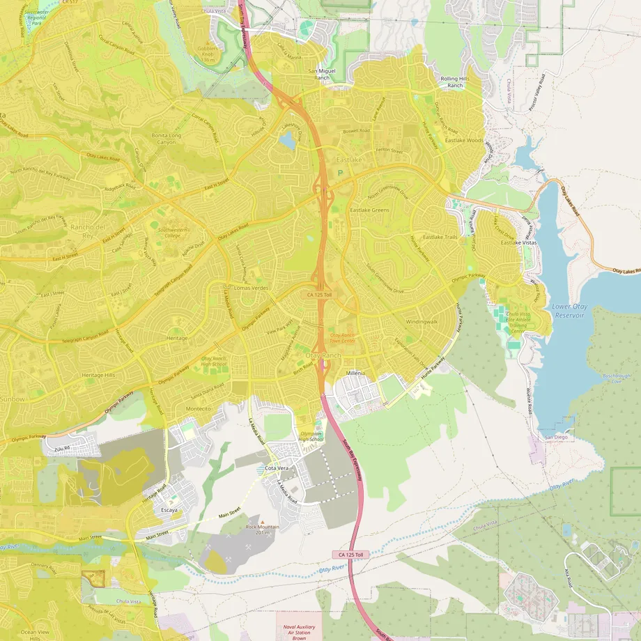
The picture uses a different measure, the U.S. Forest Service’s rating of wildfire risk to homes, so its edges won’t match the state map exactly. Look up any address on the city fire department’s hazard-zone page before an offer. A Very High zone brings stricter building rules for new work and brush-clearing rules, and it shows up in the seller’s hazard disclosure. Our guide to finding a home you can still insure covers what to ask.
What’s under the houses?
Clay is the thing to ask about. The Otay Formation, the rock layer named for this area, holds beds of bentonite clay. A San Diego County environmental report calls them highly expansive and very weak. It names them the main cause of the San Ysidro landslide complex to the southwest. California requires a soils report for every new subdivision, so one exists for each tract here. Ask for it, and have an inspector check slabs, walls and pool decks for cracks.
Flooding is a smaller worry. FEMA’s current flood map puts under 4% of the two ZIP codes in high-risk flood zones, mostly down in the Otay River valley. The Town Center and Heritage Road at Olympic Parkway are both in the minimal-risk zone.
What do the extra taxes pay for?
California’s base property tax is 1% of assessed value. An $800,000 house is close to the median owner estimate in both ZIP codes. That’s $8,000 a year. Voter-approved bonds add a little more.
Then come the special taxes. Homes here sit in community facilities districts, usually called Mello-Roos districts. Some pay back bonds for roads and parks built for new villages. Others pay for upkeep of medians, slopes, trails and the Otay Ranch Preserve. Chula Vista lists dozens of these districts. Back in 2017, KPBS counted 56, many of them east of I-805. The amounts vary by village and by house, so ask for the seller’s latest tax bill. HOA dues come on top. The guide to the true monthly cost of a home walks through the rest.
Can I add a backyard cottage?
Usually. State law allows an accessory dwelling on a single-family lot, and since 2020 an HOA can’t ban one outright. It can still set reasonable rules, so read the HOA’s rules, the CC&Rs, first.
What’s still being built?
The southern edge is still filling in, with new streets going up in the villages above the Otay River. Millenia, east of SR-125, is the plan’s urban center. The city also owns roughly 375 acres in the southeast set aside for a university and research district. A 2023 state law let the city keep negotiating with a developer. As of late 2026, nothing has been built there.
Where do people shop?
Otay Ranch Town Center, an open-air mall that opened in 2006, is the local main street. It has an AMC theater and a Barnes & Noble. Its Macy’s closed in March 2025. A Walmart Supercenter and a Home Depot sit just north on Eastlake Parkway. A Target and a Lowe’s are about 2 miles away. The nearest Costco is on East H Street, about 5 miles by road. Westfield Plaza Bonita is about 8 miles, and the outlet malls at the San Ysidro border about 10.
What do people do on weekends?
Lower Otay Reservoir, on the eastern edge, is a City of San Diego lake. It’s open for fishing on Wednesdays and weekends, sunrise to sunset. There’s no swimming, and the boat ramp has been closed for low water since June 3, 2026; check before you go. Beside it, the Chula Vista Elite Athlete Training Center opened in 1995 as an Olympic training site. The city has owned it since 2017.
South of the villages, Otay Valley Regional Park has more than eight miles of trails along the river. The North Island Credit Union Amphitheatre, about 4 miles away, books big touring acts, and its 2026 season ran into late October. Sesame Place San Diego, the theme park next door to it, reopened for 2026 in late March. Imperial Beach is about 13 miles by road, and Petco Park about 17.
How do you get around?
Olympic Parkway and Telegraph Canyon Road both lead west to I-805. SR-125, the South Bay Expressway, is a toll road. As of April 2026 tolls ran from 50 cents to $3.50. SANDAG, the regional planning agency, is studying whether to drop them, perhaps as early as 2027. Rapid 225 buses stop at Millenia, the Town Center, Santa Venetia, Lomas Verdes and Heritage. They run to downtown San Diego about every 20 minutes for most of the day.
- Downtown San Diego, about 17 miles; San Diego International Airport, about 20.
- The Otay Mesa border crossing, about 9 miles. The Cross Border Xpress bridge to Tijuana’s airport, about 8.
The southern villages fall in an airport overflight notification area on the city’s map, so new homes there come with a notice in the deed that aircraft fly overhead. Brown Field, a small airport on Otay Mesa, is about 2 miles south.
Who provides what?
- City services: Chula Vista. Its fire department has stations inside the area, on Santa Venetia Street, Millenia Avenue and Avenida Caprise.
- Water: the Otay Water District, which also irrigates many parks and medians with recycled water.
- Electricity and gas: San Diego Community Power has been the default electricity supplier since 2022. SDG&E delivers it and supplies gas.
- Trash: Republic Services, the city’s hauler, with trash, recycling and green-waste carts.
- Schools: the Chula Vista Elementary School District and the Sweetwater Union High School District. Check each district’s boundary lookup for an address.
- Hospital: Sharp Chula Vista Medical Center, about 5 miles.
- Climate: Chula Vista’s NOAA weather station, nearer the bay, averages 9.2 inches of rain a year. Its typical highs peak at about 77°F in August and September.
Facts on this page were checked against city, county, state and federal sources on November 2, 2026.
The map over Otay Ranch opens with wildfire, flood and transit switched on, if you’d like to look street by street.