East Las Vegas: a neighborhood report
Last checked
Nellis Boulevard is the line to know. West of it lies East Las Vegas, a 7-square-mile part of the City of Las Vegas. It runs from Charleston Boulevard north to Owens Avenue, and back west to Eastern Avenue. East of Nellis, the same ZIP code, 89110, is Sunrise Manor. That’s unincorporated Clark County, run by the County Commission rather than a city hall. The other ZIP, 89101, is almost all city, and its west half runs into the east edge of downtown.
Which side you’re on decides your fire department, your sewer service, your zoning rules and your tax rate. The mailing address says “Las Vegas” either way.
On the map: bus stops nearly everywhere west of Nellis
About 66,000 people live in the city’s East Las Vegas area, and buses reach nearly all of it. RTC routes run on Charleston, Stewart, Bonanza, Washington and Owens, and on Eastern, Pecos, Lamb and Nellis. The August 2026 schedule lists 288 stops on 20 routes inside the two ZIP codes. So almost every home west of Nellis has a bus stop within a short walk.
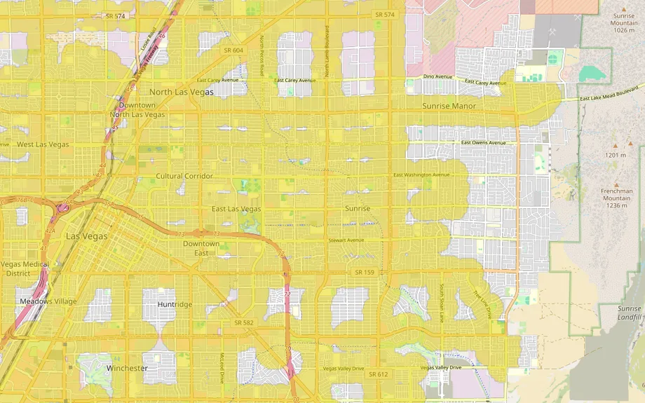
That changes toward Frenchman Mountain, where many Sunrise Manor streets have no stop close by. The RTC is planning a faster line on Charleston Boulevard, 16.9 miles from Summerlin to Nellis. It has federal money for planning, but no build date as of 2026. Our guide to living without a car covers what else to check.
Heat, flash floods and a fault
Heat is the hazard you’ll feel every year. Late July averages 105°F by day and 83°F at night. The airport hit 120°F on July 7, 2024. The city wants tree canopy over 20% of East Las Vegas by 2035. Ask how old the air conditioner is.
Rain is rare, about 4 inches a year, but summer storms come fast. Most of the area is outside FEMA’s high-risk flood zones, including Bonanza Road at Pecos and at Lamb. The high-risk zone here is mostly the channel of the Las Vegas Wash. It crosses Bonanza near Lamb and runs southeast to Nellis. In a cloudburst, water still runs down the streets, so look at where a lot drains.
The Frenchman Mountain fault runs about 11 miles along the mountain’s west foot, at the eastern edge of Sunrise Manor. Nevada’s geological survey uses a magnitude 6.6 quake on it as a planning scenario. Earthquake insurance is a separate policy.
The houses and the ground under them
In the city’s East Las Vegas area, about half the homes went up in the 1970s and 1980s. One in five is older than that. In the 2020-24 Census survey, fewer than four in ten were detached houses. The rest were apartments, duplexes, townhomes and about 1,800 mobile homes. Sunrise Manor is a little newer: across ZIP 89110, the typical home dates from 1987.
The federal soil survey rates nearly all the ground here as highly corrosive to bare steel. About half is rated highly corrosive to concrete, and much of it swells a little when wet. In an older house, ask about the water and sewer lines and any past slab repairs. The tap water is hard, about 16 grains per gallon.
Two sets of rules
On the city side, East Las Vegas is in City Council Ward 3. Part of 89101 near downtown is in Ward 5. In 2023 the council adopted a plan for the area. It calls for transit upgrades on Charleston, Eastern and Nellis and protected bike lanes on Stewart Avenue. Bonanza Road is to get trees, wider sidewalks and bike lanes. In Sunrise Manor, zoning goes through Clark County, and a town advisory board reviews local cases first.
Backyard cottages are opening up on both sides. A 2025 state law, AB 396, made larger cities and counties allow accessory dwelling units, and Clark County has changed its rules. Where a large city or county had no conforming ordinance by July 1, 2026, the law allows them on any residentially zoned lot without restriction. The city introduced its own ordinance in June 2026. Check its status with the Planning Department before you plan one.
The biggest project is on the old Desert Pines golf course, about 100 acres on Bonanza Road between Mojave and Pecos. The course closed on July 12, 2026. The plan approved in 2025 calls for more than 1,100 rental homes at a range of rents and over 400 homes for sale. Shops, a community center, a job-training center and parks are part of it too. Construction hadn’t started as of that summer.
Shopping
Errands stay close. A Walmart and a Target are both on Nellis Boulevard, about 2 miles by road from Bonanza and Lamb. A Home Depot on Lamb is under 2 miles, and a Lowe’s on East Charleston about 3.5. The nearest Costco is the Business Center near downtown, about 6.5 miles away. The nearest regular Costco is in Henderson, about 10. For malls, the Boulevard Mall and the Las Vegas North Premium Outlets are each about 6.5 miles.
What locals do for fun
Gary Reese Freedom Park is the big one. Its 68 acres on Mojave Road hold ball fields, a skate park, disc golf and a dog park, with a splash pad due in 2027. Hollywood Regional Park serves the Sunrise Manor side. Frenchman Mountain is on the doorstep, with a short, steep summit trail of roughly 2,000 feet of climb. Hike it outside summer.
Fremont Street is about 5 miles away. The Golden Knights’ arena and the Raiders’ stadium are each about 12. Lake Mead’s nearest shore is about half an hour by car, and Red Rock Canyon about 35 minutes. Skiing at Lee Canyon is a bit over an hour.
Getting around
US 95 crosses the southwest corner near Eastern and Charleston. From Bonanza and Lamb it’s about 11 miles to Harry Reid International Airport, about 20 minutes without traffic. The Strip at Flamingo Road is about 11 miles too. Nellis Air Force Base is about 5 miles northeast, and during its Red Flag exercises it warns northeast-valley residents to expect extra jet noise.
A short history
The Las Vegas Wash drains the whole valley toward what is now Lake Mead. It ran through here long before the houses did. The Army opened a gunnery school to the northeast in 1941, and it became Nellis Air Force Base in 1950. In May 1957, when North Las Vegas planned to annex the land east of the city, the county created Sunrise Manor instead. It is still unincorporated.
Services and taxes
- Police and fire: the Las Vegas Metropolitan Police Department covers both sides. Las Vegas Fire & Rescue serves the city, and the Clark County Fire Department serves Sunrise Manor.
- Utilities: NV Energy, Southwest Gas and the Las Vegas Valley Water District. Sewer is the city’s west of Nellis and the Clark County Water Reclamation District’s east of it.
- Hospitals: North Vista is about 4 miles by road, Sunrise Hospital about 6, and University Medical Center about 7.5.
- Schools: the Clark County School District, on both sides.
- Property tax: Nevada taxes 35% of a home’s taxable value, which is often below its price. The 2026-27 rate is about $3.28 per $100 of that in the city and $2.93 in Sunrise Manor. On a taxable value of $300,000, that’s about $3,440 a year in the city and $3,080 in Sunrise Manor. The bill on a primary home can rise at most 3% a year, and up to 8% on other homes. A sale ends the 3% cap until the new owner claims it with the County Assessor.
- Climate: about 4 inches of rain a year. July’s normal daily highs run from 103°F to 105°F.
Facts on this page were checked against city, county, state and federal sources on November 2, 2026.
Explore it yourself
Open the map over East Las Vegas with bus stops, flood zones and hospital access switched on. Then add what matters to you. The commute filter shows how far you’d get to work.