Āliamanu, Salt Lake and Foster Village, Honolulu: a neighborhood report
Last checked
Salt Lake was named for a real lake. It sat in a volcanic crater and was salty enough to leave salt on its shore. Most of it was filled in 1966. What’s left is a pond on the Honolulu Country Club golf course, with condo towers and houses built up around it.
The city groups Salt Lake with two neighbors. Its Neighborhood Board No. 18 covers Āliamanu, Salt Lake and Foster Village. The board area also takes in the airport, the Mapunapuna business district and part of Joint Base Pearl Harbor-Hickam. Most homes have the 96818 ZIP code, and the whole area is in City Council District 7. Honolulu is a combined city and county, so there’s no separate town government.
Towers, townhouses and houses
The Census Bureau counts close to 20,000 homes in the tracts inside the board area, base housing included. About 27% are detached houses. Another 30% are townhouses and other attached homes. Nearly a quarter are in buildings with 50 or more units. Most were built in the 1970s and 1980s, and about one in five is older than 1970.
Looking at a condo in one of the older towers? Ask about fire safety. In 2017 a fire in Honolulu’s Marco Polo tower killed four people. The building had no sprinklers. The city then passed a law requiring older residential high-rises to get a fire safety evaluation and fix what it turns up. The fire department keeps a list of the buildings the law covers. In April 2026 it included 22 buildings in ZIP code 96818, all built between 1969 and 1980. Ask the building’s association where it stands, and whether a special assessment is coming to pay for the work.
Houses have their own worry. The University of Hawaiʻi calls the Formosan subterranean termite the most damaging pest of homes in the state. Its colonies live underground, and there may be little sign of them until the damage is bad. Get a termite inspection and read it closely.
Low ground by the water
FEMA’s high-risk flood zones here are mostly in Mapunapuna, between Salt Lake and the airport, and along the shore by Lagoon Drive. In Mapunapuna they follow Moanalua Stream and cover blocks where FEMA expects shallow flooding.
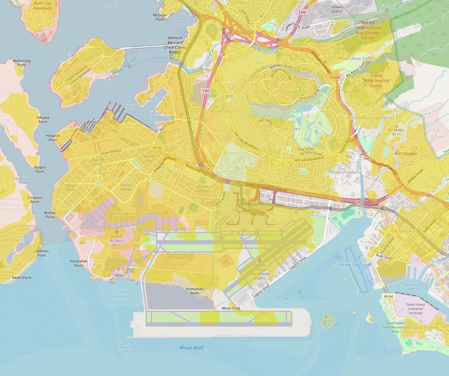
Mapunapuna also floods from the sea side. Its streets already take on water at high tide. A 2025 University of Hawaiʻi study found parts of Oʻahu’s south shore sinking about an inch a year, much faster than the sea is rising. Much of Mapunapuna is built on fill and loose sediment, which the researchers think is settling. One of them called it a ground zero for sea level rise.
Red Hill
Just northeast of the board area, the Navy stored jet fuel in huge tanks dug into Red Hill. In November 2021, fuel got into the Navy’s drinking water system, which served about 93,000 people. Homes in the Army’s Āliamanu Military Reservation, inside the crater, were on that system, and fuel smells were reported from their taps. The system was restored by March 2022, and the tanks were emptied by March 2024.
Most of Honolulu gets its water from the city’s Board of Water Supply. The board shut its own nearby Hālawa Shaft after the leak and was still working on the problem in late 2025. As of August 2026, the extent of the cleanup Red Hill still needs was undetermined.
A second home on the lot
Honolulu has allowed backyard cottages, called accessory dwelling units, since 2015 on residential lots of at least 3,500 square feet. A 2024 state law, Act 39, requires counties to allow two of them on eligible lots. The city updated its zoning code late that year. Few owners have built one. About 1,320 went up island-wide over the decade, and some areas lack the sewer capacity for more. The city’s planning director called it “not really a super successful program” in 2025.
Trains and planes
Skyline, Honolulu’s elevated rail line, reached the area on October 16, 2025. Three of its stations are inside the board area: Makalapa by Pearl Harbor, Lelepaua at the airport, and Āhua on Lagoon Drive. Trains run west to East Kapolei and east to Middle Street in Kalihi.
By road, the Moanalua Freeway and the H-1 both cross the area, and Nimitz Highway runs past the airport. Downtown Honolulu is about 6 miles from Salt Lake Shopping Center, roughly 12 minutes without traffic. The airport terminal is under 2 miles away.
That closeness has a cost. A major airport and an air base share the board area, so plan on hearing planes. How loud it gets depends on the street.
Shopping
Salt Lake Shopping Center, on Ala Lilikoi Street, has a Safeway. Target is on Lawehana Street, about 1.6 miles by road, and Home Depot is on Mapunapuna Street, about 1.4. The nearest Costco is in Iwilei, about 4 miles toward downtown. The nearest Walmart Supercenter is in Pearl City, about 6. For a mall, Pearlridge Center is about 4 miles west and Ala Moana Center about 7 miles east.
Weekends
Salt Lake District Park, on Ala Lilikoi Place, has a 50-meter pool and a smaller training pool. Hours change, so check the city’s pool schedule first.
The Aloha Stadium Swap Meet is just west, in Hālawa. It runs Wednesdays, Saturdays and Sundays. In October 2025 it moved to a lower parking lot on the stadium grounds, as the old stadium was being torn down for a rebuild. Pearl Harbor National Memorial is about 3 miles away by road.
For a walk, the state’s Kamananui Valley Road trail starts at the back of Moanalua Valley, about 4 miles by road. It follows an old road up the valley, roughly 8 miles out and back, and gets muddy after rain.
The practical details
- Utilities: Hawaiian Electric supplies power. Hawaiʻi Gas runs a gas pipeline through urban Oʻahu, so ask whether a home is connected or uses propane. The Board of Water Supply provides water, and the city handles sewer and trash.
- Hospital: Kaiser Permanente’s Moanalua Medical Center is about 2.5 miles by road.
- Schools: Hawaiʻi runs one statewide district, the Hawaiʻi State Department of Education. Its school locator gives the schools for an address.
- Property tax: for July 2026 to June 2027, owner-occupied homes pay $3.50 per $1,000 of taxable value. Owners under 65 get the first $120,000 exempt. A home assessed at $900,000 pays about $2,730 a year. A home that isn’t owner-occupied can fall in the Residential A class, which starts at $4.00 per $1,000.
- Weather: NOAA’s weather station is at the airport, inside the board area. It averages about 16 inches of rain a year, most of it from November to March. Highs run from about 80°F in January to 89°F in August, and about 32 days a year reach 90°F.
Facts on this page were checked against city, state and federal sources and local news on November 3, 2026.
The map over Salt Lake opens with flood zones, noise and transit switched on, if you want to look street by street.