North End, Tacoma: a neighborhood report
Last checked
Tacoma started here. Job Carr built a cabin above Commencement Bay in 1865, on the spot now called Old Town. The North End grew out from it, up the bluff and south to Sixth Avenue. The city’s North End Neighborhood Council covers about 4.5 square miles, from Sixth Avenue to the water. ZIP codes 98406 and 98407 hold most of it, with a corner in 98403. Those ZIPs also reach into the West End, the Stadium District and the separate small town of Ruston.
On the map: high ground above the bay
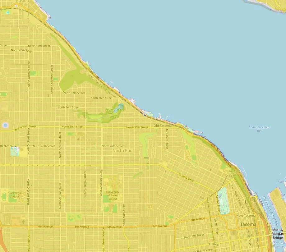
FEMA’s high-risk flood zones barely reach the North End, which sits mostly on a bluff above the bay. The Proctor business district and Old Town’s North 30th Street are in the minimal-hazard zone. The high-risk zone is a thin coastal strip along the Ruston Way waterfront, at the foot of the bluff.
Earthquakes are the bigger natural risk. Researchers place the Tacoma fault zone just to the north, near Point Defiance. Washington added building rules for tsunami-prone shoreline in March 2024. Price earthquake insurance, and ask whether an older house is bolted to its foundation.
What’s in the soil
For nearly a century a copper smelter ran on the shore at Ruston, just past the North End’s northwest corner. It closed in 1985, and its smokestack was brought down on January 17, 1993. Arsenic and lead from its smoke settled on the soil across more than 1,000 square miles of the Puget Sound region.
The North End was near the source. From 1993 to 2011 the EPA sampled 3,570 properties in Ruston and North Tacoma and replaced the soil at 2,436 of them. That work covered about a square mile around the smelter. The state Department of Ecology still offers free sampling and soil replacement where contamination is highest.
Before you buy, look the address up on Ecology’s Dirt Alert map. It shows sampling results and any soil replacement on record. Washington sellers must disclose known soil contamination. Ecology says the long-term health risk is very small in most areas, and it publishes simple habits for gardening in plume soil.
Old houses, and what comes with them
The houses are old. Five Census tracts make up most of the North End. In them, about half the homes were built before 1940 and seven in ten before 1960. Only one in twenty dates from 2010 or later. Nearly three in four are detached houses.
That age shows up in inspections. Federal law requires a seller of a pre-1978 home to disclose known lead-based paint. In Tacoma the owner is responsible for the side sewer. That’s the pipe from the house all the way to the city main. The city runs a loan program to help with repairs, so have the line scoped. About half the homes heat with gas and most of the rest with electricity. A few still burn heating oil, so ask about any old oil tank.
Historic districts and the new zoning
Two local historic districts sit in the North End: the North Slope, near the Stadium District, and the Wedge, between Sixth and Division avenues. In either one, exterior work that needs a building permit goes before the city’s Landmarks Preservation Commission first. The College Park district is on the National Register, not the city’s, so it carries no local permit review.
Across the city, the rules loosened on February 1, 2025. The city’s Home in Tacoma zoning replaced single-family zoning everywhere. House-plexes, backyard cottages, rowhouses and small apartment buildings are now allowed on many residential lots. In its first year the city logged 213 applications for 385 homes citywide. Around North 26th and Proctor, several six-story apartment buildings have gone up over the past decade, and another has been proposed.
Shopping
The North End shops in small business districts. Proctor has two full grocery stores, and Sixth Avenue, Old Town and the Stadium District each have their own strip. For bigger trips, a Target, a Walmart Supercenter and a Fred Meyer are each about 2.5 miles by road. Costco and a Home Depot are about 3.5 miles, and the Tacoma Mall about 4.5.
What locals do for fun
Ruston Way is the front porch. A paved path runs along the water past a string of small parks and restaurants. It continues past Ruston to Point Defiance Park, 760 acres of forest, beach and gardens about 4.5 miles from Proctor. Its outer loop road has been closed to cars since 2022. Owen Beach reopened in June 2022 after a 16-month rebuild. The zoo and aquarium charge admission; parking in the park is free.
On Saturdays from April to mid-December, the Proctor Farmers’ Market sets up at North 27th and Proctor. The Proctor Arts Fest takes over North 26th and Proctor each August; the 2026 one was August 1. The Blue Mouse Theatre, a single-screen cinema on Proctor, still shows films and live events. The Tacoma Rainiers play baseball about 3 miles away. Snoqualmie Pass is about an hour and a half by car, and Crystal Mountain and Mount Rainier’s Paradise about two hours or more.
Getting around
Downtown Tacoma is about 3 miles by road, Sea-Tac Airport about 25 and downtown Seattle about 37. Sound Transit’s T Line streetcar reaches the Stadium District at North 1st and G streets, and Pierce Transit buses run the arterials. From the Point Defiance terminal, about 4 miles from Proctor, a state ferry crosses to Vashon Island. A freight rail line runs along the Ruston Way shoreline, below the bluff.
Services, taxes and climate
- Utilities: Tacoma Power and Tacoma Water, both city-owned. Puget Sound Energy supplies natural gas. The city collects garbage and runs the sewer.
- Snow: the city plows and de-ices main routes, not residential streets. Owners must clear the sidewalk within 24 hours.
- Hospitals: MultiCare Tacoma General is about 2 miles away and St. Joseph Medical Center about 3.
- Schools: Tacoma Public Schools. Check the district’s boundary tool for an address.
- Property tax: Washington has no state income tax. In the 2020-24 Census survey, the median yearly property tax bill in the North End’s tracts ran from about $4,700 to $8,000. That’s roughly 0.8% to 1% of the median home value.
- Climate: about 41 inches of rain a year, mostly fall to spring, and about 6 inches of snow at Sea-Tac.
Facts on this page were checked against city, county, state and federal sources on November 2, 2026.
Explore it yourself
Open the map over the North End with flood zones, walkability and parks switched on, then add what matters to you.